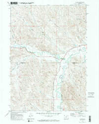
1970 Map of Ucross
USGS Topo · Published 1973About this map
Clear Creek and Piney Creek converge near Ucross in this Wyoming landscape, where an intricate network of irrigation systems defines the local economy and geography. Extensive water works like the Big Bonanza Ditch, Des Moines Ditch, and Pratt and Ferris Ditch illustrate the scale of hydraulic engineering required to support ranching and agriculture in the semi-arid region. The map captures the boundary between Sheridan and Johnson counties, showing a terrain marked by named drainages such as Bourret Draw and Donkey Creek. Notable landmarks like Blazer Hill and the Pitsch Res stand alongside utilitarian features like the Gravel Pit and various Jeep Trails, providing a detailed record of land use and water management in the early 1970s.
Find a feature on this map
28 named features on this map. Tap any name to fly to it.
Don’t see what you’re looking for? This feature index may not catch every label — zoom into the map to look around manually.
Map Details
Editions of this 1970 Ucross Map
2 editions found
Other maps of this area

1900 · Fort McKinney
USGS Topo · 1:125,000

1903 · Fort McKinney
USGS Topo · 1:125,000

1909 · Sheridan
USGS Topo · 1:125,000

1911 · Sheridan
USGS Topo · 1:125,000

1955 · Sheridan
USGS Topo · 1:250,000

1958 · Sheridan
USGS Topo · 1:250,000

1962 · Sheridan
USGS Topo · 1:250,000

1970 · Buffalo NE
USGS Topo · 1:24,000
1970 · Horse Hill
USGS Topo · 1:24,000
1970 · Verona
USGS Topo · 1:24,000