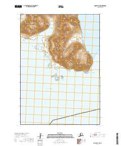
2019 Map of Ugashik B-1 NE
USGS Topo · Published 2019About this map
The remote and mountainous coastline of the Alaska Kodiak Island Borough meets the high-latitude waters of the Pacific Ocean in this 2019 survey. The terrain is dominated by steep coastal ridges that descend sharply toward the sheltered waters of Portage Bay and the prominent headland of Cape Igvak. This is a landscape shaped by glacial topography and maritime isolation, where no roads or permanent settlements appear on the map, leaving the natural features and township boundaries such as t31s r42w as the primary markers of location. The map provides a detailed view of the coastal relief and the intricate shoreline that defines this portion of the Alaska Peninsula.
Find a feature on this map
8 named features on this map. Tap any name to fly to it.
Don’t see what you’re looking for? This feature index may not catch every label — zoom into the map to look around manually.
Map Details
Editions of this 2019 Ugashik B-1 NE Map
This is the sole edition of this map. No revisions or reprints were ever made.
Other maps of this area

1943 · Ugashik
USGS Topo · 1:250,000

1948 · Ugashik
USGS Topo · 1:250,000

1949 · Ugashik
USGS Topo · 1:250,000

1951 · Karluk
USGS Topo · 1:250,000

1951 · Ugashik B-1
USGS Topo · 1:63,360

1951 · Ugashik C-1
USGS Topo · 1:63,360
1951 · Karluk C-6
USGS Topo · 1:63,360

1952 · Karluk
USGS Topo · 1:250,000

1963 · Ugashik
USGS Topo · 1:250,000

1964 · Karluk
USGS Topo · 1:250,000