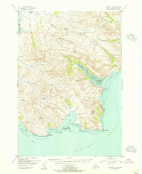
1951 Map of Karluk C-6
USGS Topo · Published 1956About this map
S H E L I K O F S T R A I T borders this stretch of the Alaska Peninsula, where a complex network of coastal inlets and steep ridges defines the landscape in 1951. The topography is marked by significant drainages such as Salmon Creek and Bear Creek, which cut through the high ground between the coast and the inland reach of Becharof Lake. Along the shoreline, deep indentations like Island Bay and Jute Bay are protected by landmarks such as Pinnacle Rk and the Jute Islands. A few isolated structures, simply labeled Cabin, appear near the water's edge, suggesting seasonal or resource-based habitation in an area primarily defined by its hydrography and natural landmarks like Jute Peak. The mapping of Dry Bay reveals an extensive Tidal Flat, illustrating the dynamic maritime environment before later geological changes or modern development altered these remote reaches.
Find a feature on this map
31 named features on this map. Tap any name to fly to it.
Don’t see what you’re looking for? This feature index may not catch every label — zoom into the map to look around manually.
Map Details
Editions of this 1951 Karluk C-6 Map
3 editions found
Other maps of this area

1943 · Ugashik
USGS Topo · 1:250,000

1948 · Ugashik
USGS Topo · 1:250,000

1949 · Ugashik
USGS Topo · 1:250,000

1951 · Karluk
USGS Topo · 1:250,000

1951 · Ugashik B-1
USGS Topo · 1:63,360

1951 · Ugashik D-1
USGS Topo · 1:63,360

1951 · Ugashik C-1
USGS Topo · 1:63,360

1951 · Karluk D-6
USGS Topo · 1:63,360
1951 · Karluk C-4 and C-5
USGS Topo · 1:63,360

1951 · Karluk D-5
USGS Topo · 1:63,360