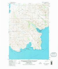
1951 Map of Karluk C-6
USGS Topo · Published 1977About this map
Becharof Lake and its surrounding drainage systems dominate this mid-century Alaskan survey, where the interior wilderness meets the coastal indentations of the Shelikof Strait. The landscape is defined by the proximity of the Pacific to the freshwater of the lake, separated by a series of steep drainages such as Becharof Creek and Salmon Creek. Human presence is minimal and functional, marked by a remote Cabin on Island Bay and a Landing Strip situated along the coastal flats. This era of mapping captured the area before widespread modern development, showing the natural state of inlets like Dry Bay and Jute Bay. Navigational landmarks such as Cape Kanatak and Cape Unalishagvak anchored the shoreline for maritime activity, while Jute Peak served as a prominent inland reference point for those navigating the rugged Aleutian Range foothills.
Find a feature on this map
32 named features on this map. Tap any name to fly to it.
Don’t see what you’re looking for? This feature index may not catch every label — zoom into the map to look around manually.
Map Details
Editions of this 1951 Karluk C-6 Map
3 editions found
Other maps of this area

1943 · Ugashik
USGS Topo · 1:250,000

1948 · Ugashik
USGS Topo · 1:250,000

1949 · Ugashik
USGS Topo · 1:250,000

1951 · Karluk
USGS Topo · 1:250,000

1951 · Ugashik B-1
USGS Topo · 1:63,360

1951 · Ugashik D-1
USGS Topo · 1:63,360

1951 · Ugashik C-1
USGS Topo · 1:63,360

1951 · Karluk D-6
USGS Topo · 1:63,360
1951 · Karluk C-4 and C-5
USGS Topo · 1:63,360

1951 · Karluk D-5
USGS Topo · 1:63,360