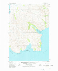
1951 Map of Karluk C-6
USGS Topo · Published 1977About this map
Shelikof Strait borders a coastline defined by deep inlets and industrial potential in this 1951 topographic study. The landscape is marked by the rugged coastal geometry of Dry Bay, Island Bay, and Jute Bay, where the Tidal Flat meets the mainland. Early 1950s exploration efforts are evident near the Oil Creek drainage, where an Oil Well and a nearby Landing Strip indicate the area's mid-century petroleum interest. Inland, the terrain rises toward Jute Peak and is bisected by numerous drainages like Becharof Creek and Rex Creek. Small signs of seasonal habitation or remote work appear as a Cabin near the shores of Island Bay. To the north, the massive reach of Becharof Lake and its corresponding Becharof Bay suggest the vital freshwater-to-saltwater corridors that historically supported travel and resource extraction along this stretch of the Alaska Peninsula.
Find a feature on this map
33 named features on this map. Tap any name to fly to it.
Don’t see what you’re looking for? This feature index may not catch every label — zoom into the map to look around manually.
Map Details
Editions of this 1951 Karluk C-6 Map
3 editions found
Other maps of this area

1943 · Ugashik
USGS Topo · 1:250,000

1948 · Ugashik
USGS Topo · 1:250,000

1949 · Ugashik
USGS Topo · 1:250,000

1951 · Karluk
USGS Topo · 1:250,000

1951 · Ugashik B-1
USGS Topo · 1:63,360

1951 · Ugashik D-1
USGS Topo · 1:63,360

1951 · Ugashik C-1
USGS Topo · 1:63,360

1951 · Karluk D-6
USGS Topo · 1:63,360
1951 · Karluk C-4 and C-5
USGS Topo · 1:63,360

1951 · Karluk D-5
USGS Topo · 1:63,360