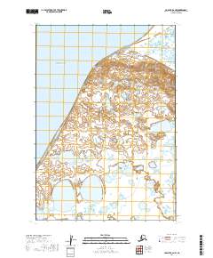
2019 Map of Ugashik B-6 NW
USGS Topo · Published 2019About this map
Cape Menshikof defines the shoreline of the Alaska Peninsula in this coastal survey, where the land meets the cold waters of Bristol Bay. The terrain is a complex network of thousands of small kettle lakes and ponds, characteristic of the low-lying tundra landscape in this part of the Lake and Peninsula Borough. Topographic contours reveal a series of coastal bluffs and ridges that rise from the bay, contrasting with the saturated, lake-pocked interior plains. The map is primarily an environmental record of an undeveloped wilderness, documenting the precise location of the cape and the intricate hydrography of the surrounding wetlands as they existed in the early twenty-first century.
Find a feature on this map
6 named features on this map. Tap any name to fly to it.
Don’t see what you’re looking for? This feature index may not catch every label — zoom into the map to look around manually.
Map Details
Editions of this 2019 Ugashik B-6 NW Map
This is the sole edition of this map. No revisions or reprints were ever made.
Other maps of this area

1943 · Ugashik
USGS Topo · 1:250,000

1948 · Ugashik
USGS Topo · 1:250,000

1949 · Ugashik
USGS Topo · 1:250,000

1951 · Bristol Bay
USGS Topo · 1:250,000

1951 · Ugashik C-6
USGS Topo · 1:63,360

1963 · Ugashik B-6
USGS Topo · 1:63,360

1963 · Bristol Bay
USGS Topo · 1:250,000
1963 · Bristol Bay B-1
USGS Topo · 1:63,360

1963 · Ugashik
USGS Topo · 1:250,000
1967 · Bristol Bay
USGS Topo · 1:250,000