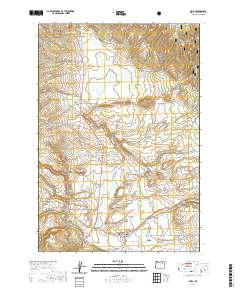
2020 Map of Ukiah
USGS Topo · Published 2020About this map
The settlement of Ukiah serves as the central hub of this modern survey, positioned at the confluence of several high-desert waterways and regional corridors. The landscape is defined by the headwaters and tributaries of Camas Cr, including Snipe Cr, Owens Cr, and Deerlick Cr, which carve through the surrounding terrain. To the north and south, the Umatilla National Forest provides a backdrop of protected land, while local water management is evident in features like Kottmeier Reservoir, Leverenz Reservoir, and the Weissenfluh Reservoir. Genealogists and local historians can pinpoint several significant landmarks, notably the Sturdivant Cem located west of the town center and the Ukiah Cem just to the east. Transportation into the deeper canyon lands is facilitated by routes such as Albee Rd and the Ukiah-Granite Road 52 (Snow), highlighting the area's role as a gateway to the Randall Canyon and Johnson Canyon regions.
Find a feature on this map
36 named features on this map. Tap any name to fly to it.
Don’t see what you’re looking for? This feature index may not catch every label — zoom into the map to look around manually.
Map Details
Editions of this 2020 Ukiah Map
This is the sole edition of this map. No revisions or reprints were ever made.
Other maps of this area

1953 · Pendleton
USGS Topo · 1:250,000

1956 · Pendleton
USGS Topo · 1:250,000

1967 · Ukiah SE
USGS Topo · 1:24,000

1967 · Granite Meadows
USGS Topo · 1:24,000

1967 · Bridge Creek
USGS Topo · 1:24,000

1967 · Carney Butte
USGS Topo · 1:24,000

1967 · Ukiah
USGS Topo · 1:24,000

1967 · Owens Butte
USGS Topo · 1:24,000

1968 · Gurdane
USGS Topo · 1:24,000

1969 · Sugarbowl Creek
USGS Topo · 1:24,000