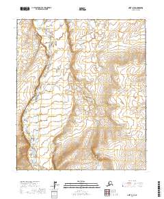
2017 Map of Umiat A-2 SE
USGS Topo · Published 2017About this map
The Nanushuk River dominates the western portion of this 2017 survey in the North Slope Borough, carving a distinct path through the arctic tundra. The river's meander patterns and adjacent lowlands contrast sharply with the rising elevation found elsewhere on the quadrangle. A primary geographic landmark is the Shale Wall Bluff, which overlooks the river valley and serves as a significant topographical marker in this expansive landscape. The map provides a detailed view of the terrain before the more mountainous regions to the south, highlighting the complex drainage systems and natural relief of this remote part of Alaska. While largely devoid of man-made structures, the map captures the untouched character of the North Slope's interior wilderness.
Find a feature on this map
6 named features on this map. Tap any name to fly to it.
Don’t see what you’re looking for? This feature index may not catch every label — zoom into the map to look around manually.
Map Details
Editions of this 2017 Umiat A-2 SE Map
This is the sole edition of this map. No revisions or reprints were ever made.
Other maps of this area

1951 · Chandler Lake
USGS Topo · 1:250,000

1952 · Umiat
USGS Topo · 1:250,000

1956 · Chandler Lake
USGS Topo · 1:250,000

1956 · Umiat
USGS Topo · 1:250,000

1964 · Chandler Lake
USGS Topo · 1:250,000

1964 · Umiat
USGS Topo · 1:250,000
1971 · Chandler Lake D-1
USGS Topo · 1:63,360

1971 · Umiat A-2
USGS Topo · 1:63,360
1971 · Chandler Lake D-2
USGS Topo · 1:63,360
1971 · Umiat A-1
USGS Topo · 1:63,360