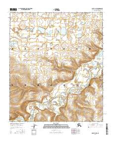
2016 Map of Umiat A-3 NW
USGS Topo · Published 2016About this map
Chandler River winds through this Arctic landscape, carving a deep path beneath the prominent Paunagaktuk Bluff and the rising Tuluvak Bluffs. This 2016 survey by the U.S. Geological Survey captures a wild stretch of the North Slope, where the drainage of Trouble Cr meets the main river valley. The terrain is defined by a network of tundra lakes and thermokarst features in the northern sections, transitioning into the sharp relief of the river bluffs to the south. The survey provides a detailed look at the hydrology and landforms of this region before any major industrial footprint, mapping the township and range lines across a territory primarily shaped by natural geologic and glacial forces.
Find a feature on this map
13 named features on this map. Tap any name to fly to it.
Don’t see what you’re looking for? This feature index may not catch every label — zoom into the map to look around manually.
Map Details
Editions of this 2016 Umiat A-3 NW Map
This is the sole edition of this map. No revisions or reprints were ever made.
Other maps of this area

1952 · Umiat
USGS Topo · 1:250,000

1955 · Umiat B-4
USGS Topo · 1:63,360

1955 · Umiat A-4
USGS Topo · 1:63,360

1955 · Umiat A-3
USGS Topo · 1:63,360

1955 · Umiat B-3
USGS Topo · 1:63,360

1956 · Umiat
USGS Topo · 1:250,000

1964 · Umiat
USGS Topo · 1:250,000
2016 · Umiat A-3 NE
USGS Topo · 1:25,000
2016 · Umiat A-4 NE
USGS Topo · 1:25,000
2016 · Umiat B-4 SE
USGS Topo · 1:25,000