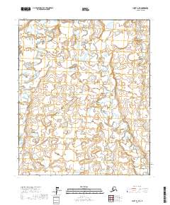
2017 Map of Umiat B-1 NE
USGS Topo · Published 2017About this map
The Kuparik River meanders across this northern landscape, defining the hydrology of the area south of the Arctic coast. This 2017 survey by the U.S. Geological Survey illustrates the transition from the upper tundra plains into the river's drainage basin, showing a complex network of wetlands and small water bodies that characterize the North Slope Borough. The map provides a detailed view of the Public Land Survey System grid, documenting various townships including t2n r8e and t1n r8e during a period of modern geographic inventory. For researchers and environmental historians, the sheet offers a precise record of the shoreline and elevation contours of the river's path before shifting seasons and permafrost changes alter the terrain.
Find a feature on this map
9 named features on this map. Tap any name to fly to it.
Don’t see what you’re looking for? This feature index may not catch every label — zoom into the map to look around manually.
Map Details
Editions of this 2017 Umiat B-1 NE Map
This is the sole edition of this map. No revisions or reprints were ever made.
Other maps of this area

1951 · Sagavanirktok D-5
USGS Topo · 1:250,000

1952 · Umiat
USGS Topo · 1:250,000

1956 · Sagavanirktok
USGS Topo · 1:250,000

1956 · Umiat
USGS Topo · 1:250,000

1958 · Sagavanirktok
USGS Topo · 1:250,000

1964 · Umiat
USGS Topo · 1:250,000

1964 · Sagavanirktok
USGS Topo · 1:250,000
1971 · Umiat C-1
USGS Topo · 1:63,360
1971 · Sagavanirktok B-5
USGS Topo · 1:63,360
1971 · Sagavanirktok C-5
USGS Topo · 1:63,360