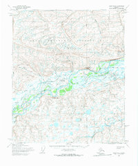
1955 Map of Umiat B-4
USGS Topo · Published 1970About this map
The remote settlement of Umiat serves as a focal point in this 1955 survey of the North Slope, situated at a strategic bend of the Colville River. This area is characterized by its role within the Naval Petroleum Reserve No 4, reflecting the mid-century push for Arctic resource exploration. The landscape is defined by prominent topographical features such as Umiat Mountain and the steep Shivugak Bluff, which overlook the river valley. The presence of the Umiat Airfield and numerous Winter Trail routes indicates the seasonal and aviation-dependent nature of transport in this roadless wilderness. Notable water bodies including Umiat Lake and the Kutchik River meander through the tundra, while the Umiat Meridian provides the foundational surveying line for this vast Alaskan interior.
Find a feature on this map
18 named features on this map. Tap any name to fly to it.
Don’t see what you’re looking for? This feature index may not catch every label — zoom into the map to look around manually.
Map Details
Editions of this 1955 Umiat B-4 Map
2 editions found
Other maps of this area

1952 · Umiat
USGS Topo · 1:250,000

1955 · Umiat B-4
USGS Topo · 1:63,360

1955 · Umiat C-4
USGS Topo · 1:63,360

1955 · Umiat A-4
USGS Topo · 1:63,360

1955 · Umiat A-5
USGS Topo · 1:63,360

1955 · Umiat A-3
USGS Topo · 1:63,360

1955 · Umiat C-5
USGS Topo · 1:63,360

1955 · Umiat C-3
USGS Topo · 1:63,360

1955 · Umiat B-5
USGS Topo · 1:63,360

1955 · Umiat B-3
USGS Topo · 1:63,360