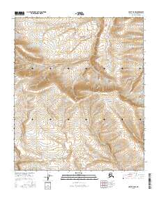
2016 Map of Umiat B-5 NW
USGS Topo · Published 2016About this map
Kikiakrorak River and Kogosukruk River carve through the North Slope terrain in this 2016 survey of the Umiat B-5 NW region. The landscape is defined by the shifting courses of these northern waterways, including the winding Rainy Cr to the southeast. This map illustrates the intricate drainage patterns across the Arctic coastal plain before the rivers reach the Colville further north. The absence of roads or permanent settlements in this area highlights the preserved wilderness and hydrological complexity of the Brooks Range foothills, providing a clear reference for the natural contours and riparian corridors of this remote Alaskan environment.
Find a feature on this map
12 named features on this map. Tap any name to fly to it.
Don’t see what you’re looking for? This feature index may not catch every label — zoom into the map to look around manually.
Map Details
Editions of this 2016 Umiat B-5 NW Map
This is the sole edition of this map. No revisions or reprints were ever made.
Other maps of this area

1951 · Ikpikpuk River
USGS Topo · 1:250,000

1952 · Umiat
USGS Topo · 1:250,000

1955 · Umiat C-5
USGS Topo · 1:63,360

1955 · Umiat B-5
USGS Topo · 1:63,360

1956 · Ikpikpuk River
USGS Topo · 1:250,000

1956 · Umiat
USGS Topo · 1:250,000

1964 · Umiat
USGS Topo · 1:250,000
1985 · Ikpikpuk River C-1
USGS Topo · 1:63,360
1985 · Ikpikpuk River B-1
USGS Topo · 1:63,360
2013 · Ikpikpuk River B-1 NE
USGS Topo · 1:25,000