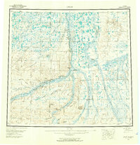
1956 Map of Umiat
USGS Topo · Published 1966About this map
The Colville River and its major tributaries dominate this mid-century survey of Alaska's North Slope, centering on the remote settlement of Umiat. Located just north of Umiat Mountain, this outpost served as a critical hub for Arctic exploration and energy research during the 1950s. The map delineates the extensive Naval Petroleum Reserve No 4, reflecting the era's strategic focus on northern resource potential. The landscape is marked by the winding courses of the Anaktuvuk River and Killik River, alongside the industrial presence of the Gubik Gas Field. Long-distance transport is represented by a network of Tractor Trails that cross the tundra, connecting isolated landmarks like Sentinel Hill and Outpost Mountain. Surveying foundations are evident in the inclusion of the Umiat Principal Meridian and its associated Base Line, which established the cadastral framework for this vast territory.
Find a feature on this map
42 named features on this map. Tap any name to fly to it.
Don’t see what you’re looking for? This feature index may not catch every label — zoom into the map to look around manually.
Map Details
Editions of this 1956 Umiat Map
4 editions found

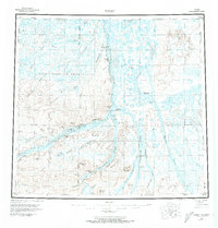
Other maps of this area

1951 · Harrison Bay
USGS Topo · 1:250,000

1951 · Beechey Point
USGS Topo · 1:250,000

1951 · Sagavanirktok D-5
USGS Topo · 1:250,000

1951 · Teshekpuk
USGS Topo · 1:250,000

1951 · Ikpikpuk River
USGS Topo · 1:250,000

1951 · Chandler Lake
USGS Topo · 1:250,000

1951 · Brooks
USGS Topo · 1:250,000

1951 · Killik River
USGS Topo · 1:250,000

1952 · Umiat
USGS Topo · 1:250,000

1955 · Harrison Bay
USGS Topo · 1:250,000