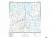
1956 Map of Umiat
USGS Topo · Published 1988About this map
Umiat serves as a focal point for this mid-century survey of the North Slope, situated where the Colville River bends through a landscape of distinctive river bluffs and drainage systems. This area is characterized by the intersection of several major arctic waterways, including the Anaktuvuk River, Chandler River, and Itkillik River, which cut through the National Petroleum Reserve in Alaska. The presence of the Umiat Gas Field and the Umiat Field reflects the mid-20th-century exploration for natural resources in the region.
Find a feature on this map
45 named features on this map. Tap any name to fly to it.
Don’t see what you’re looking for? This feature index may not catch every label — zoom into the map to look around manually.
Map Details
Editions of this 1956 Umiat Map
4 editions found

Other maps of this area

1951 · Harrison Bay
USGS Topo · 1:250,000

1951 · Beechey Point
USGS Topo · 1:250,000

1951 · Sagavanirktok D-5
USGS Topo · 1:250,000

1951 · Teshekpuk
USGS Topo · 1:250,000

1951 · Ikpikpuk River
USGS Topo · 1:250,000

1951 · Chandler Lake
USGS Topo · 1:250,000

1951 · Brooks
USGS Topo · 1:250,000

1951 · Killik River
USGS Topo · 1:250,000

1952 · Umiat
USGS Topo · 1:250,000

1955 · Harrison Bay
USGS Topo · 1:250,000