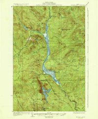
1935 Map of Umsaskis Lake
USGS Topo · Published 1935About this map
Umsaskis Lake and Long Lake form the central artery of this 1930s northern Maine wilderness, a landscape defined by the Allagash River waterway and the timber industry. The map illustrates a transitional era where traditional logging operations relied on seasonal outposts and overland routes like the Realty Tote Road and Chase Road. Remote habitations are limited to specialized sites such as Harvey Farm, the American Realty Depot Camp, and Blanchette Camp, indicating a landscape managed for resource extraction rather than permanent settlement. The presence of a Fire Tower near Priestly Lake and several Fire Warden Camps underscores the high stakes of forest protection in this timber-rich region. The Long Lake Dam at the northern end of its namesake lake suggests the managed flow of water necessary for driving logs downstream toward the Allagash Falls.
Find a feature on this map
51 named features on this map. Tap any name to fly to it.
Don’t see what you’re looking for? This feature index may not catch every label — zoom into the map to look around manually.
Map Details
Editions of this 1935 Umsaskis Lake Map
3 editions found
Other maps of this area

1932 · Umsaskis Lake
USGS Topo · 1:48,000

1932 · Musquacook Lakes
USGS Topo · 1:48,000

1932 · Allagash Falls
USGS Topo · 1:48,000

1935 · Umsaskis Lake
USGS Topo · 1:62,500

1935 · Musquacook Lakes
USGS Topo · 1:62,500

1935 · Allagash Falls
USGS Topo · 1:62,500

1954 · Spider Lake
USGS Topo · 1:62,500

1954 · Churchill Lake
USGS Topo · 1:62,500

1954 · Allagash Lake
USGS Topo · 1:62,500

1954 · Presque Isle
USGS Topo · 1:250,000