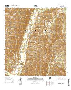
2015 Map of Unalakleet B-4 SE
USGS Topo · Published 2015About this map
The Anvik River meanders through this remote stretch of the Nulato Hills, defining a landscape of high ridges and winding valley floors in the Alaskan interior. This 2015 survey documents the transition between administrative zones, specifically the boundary separating the Nome Census Area from the Yukon-Koyukuk Census Area. The terrain is characterized by a dense network of drainages and seasonal watercourses, including the modest flow of Otter Creek in the southwestern corner. There is a total absence of built infrastructure or established roads, reflecting the isolation of the Nulato Hills region at this time. The map provides a detailed record of the natural topography and hydrography, capturing the untouched state of the land as it remained well into the 21st century.
Find a feature on this map
10 named features on this map. Tap any name to fly to it.
Don’t see what you’re looking for? This feature index may not catch every label — zoom into the map to look around manually.
Map Details
Editions of this 2015 Unalakleet B-4 SE Map
This is the sole edition of this map. No revisions or reprints were ever made.
Other maps of this area

1951 · Unalakleet
USGS Topo · 1:250,000

1952 · Unalakleet A-4
USGS Topo · 1:63,360

1952 · Unalakleet A-3
USGS Topo · 1:63,360

1952 · Unalakleet B-4
USGS Topo · 1:63,360

1952 · Unalakleet B-3
USGS Topo · 1:63,360

1952 · Unalakleet
USGS Topo · 1:250,000

1964 · Unalakleet
USGS Topo · 1:250,000
2015 · Unalakleet B-4 NE
USGS Topo · 1:25,000
2015 · Unalakleet B-3 NW
USGS Topo · 1:25,000
2015 · Unalakleet A-3 NW
USGS Topo · 1:25,000