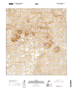
2017 Map of Unalakleet B-6 SE
USGS Topo · Published 2017About this map
The Sisters stand as a prominent topographic landmark in this stretch of the Alaskan interior, located within the Nome Census Area. This map, based on data updated through 2017, illustrates a landscape defined by its complex drainage systems and varied elevation. The Nikitarik River flows through the southeastern portion of the quadrangle, while Quekilok Cr carves through the northern reaches. The terrain is structured by the Public Land Survey System, showing the intersections of several townships including t25s r16w and t25s r15w. The absence of roads or established settlements emphasizes the remote nature of this wilderness area, where natural watercourses and named mountain features serve as the primary markers for navigation and geographic study.
Find a feature on this map
9 named features on this map. Tap any name to fly to it.
Don’t see what you’re looking for? This feature index may not catch every label — zoom into the map to look around manually.
Map Details
Editions of this 2017 Unalakleet B-6 SE Map
This is the sole edition of this map. No revisions or reprints were ever made.
Other maps of this area

1951 · Unalakleet
USGS Topo · 1:250,000

1952 · Unalakleet A-5
USGS Topo · 1:63,360

1952 · Unalakleet B-6
USGS Topo · 1:63,360

1952 · Unalakleet B-5
USGS Topo · 1:63,360

1952 · Unalakleet A-6
USGS Topo · 1:63,360

1952 · Unalakleet
USGS Topo · 1:250,000

1964 · Unalakleet
USGS Topo · 1:250,000
2017 · Unalakleet A-6 NE
USGS Topo · 1:25,000
2017 · Unalakleet B-5 NW
USGS Topo · 1:25,000
2017 · Unalakleet B-6 SW
USGS Topo · 1:25,000