
1956 Map of Unap Mountain
USGS Topo · Published 1959About this map
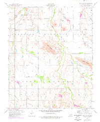
The Rainy Mountain Indian School Reservation occupies a significant portion of this Kiowa County landscape, marking a central point of institutional history in the mid-1950s. The terrain is defined by prominent elevations including Rainy Mountain, Unap Mountain, and Longhorn Mountain, which rise above the surrounding plains. The small community of Sedan sits in the northeast corner, while the Union Dale Cemetery serves as a localized genealogical landmark in the southwest. This map records the drainage patterns of the area, notably Rainy Mountain Creek, Longhorn Creek, and Sugar Creek, illustrating how these watercourses navigate the township boundaries of Harrison, Mountain View, Cooper, and Marshall. The survey captures the rural character of the region just as photogrammetric mapping was refining the precision of Oklahoma's topographic records.
Find a feature on this map
13 named features on this map. Tap any name to fly to it.
Don’t see what you’re looking for? This feature index may not catch every label — zoom into the map to look around manually.
Map Details
Editions of this 1956 Unap Mountain Map
2 editions found
Other maps of this area

1949 · Cooperton
USGS Topo · 1:62,500

1950 · Saddle Mountain
USGS Topo · 1:62,500

1955 · Lawton
USGS Topo · 1:250,000

1955 · Clinton
USGS Topo · 1:250,000

1956 · Glen Mountains
USGS Topo · 1:24,000

1956 · Saddle Mountain
USGS Topo · 1:24,000

1956 · Cooperton
USGS Topo · 1:24,000

1956 · Bally Mountain
USGS Topo · 1:24,000

1956 · Rainy Mountain Creek
USGS Topo · 1:24,000

1956 · Saddle Mountain
USGS Topo · 1:62,500