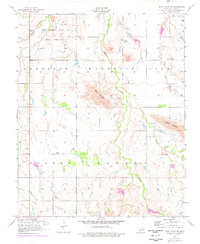
1956 Map of Unap Mountain
USGS Topo · Published 1976About this map
Rainy Mountain and Unap Mountain dominate the horizon of this Kiowa County landscape, which transitions between the rugged peaks of the Wichita Mountains and the surrounding plains during the mid-1950s. The northern portion of the map is largely defined by the Indian Reservation, where Rainy Mountain Creek flows past the base of its namesake height. This 1956 survey, with 1975 revisions shown in purple, illustrates the rural development of the era, from the small settlement of Sedan in the northeast to the Union Dale Cemetery further south. The drainage patterns of Sugar Creek and Longhorn Creek carve through the townships of Harrison, Mountain View, Cooper, and Marshall, revealing the natural corridors that influenced local road networks and land use in this part of southwestern Oklahoma.
Find a feature on this map
13 named features on this map. Tap any name to fly to it.
Don’t see what you’re looking for? This feature index may not catch every label — zoom into the map to look around manually.
Map Details
Editions of this 1956 Unap Mountain Map
2 editions found
Other maps of this area

1949 · Cooperton
USGS Topo · 1:62,500

1950 · Saddle Mountain
USGS Topo · 1:62,500

1955 · Lawton
USGS Topo · 1:250,000

1955 · Clinton
USGS Topo · 1:250,000

1956 · Glen Mountains
USGS Topo · 1:24,000

1956 · Saddle Mountain
USGS Topo · 1:24,000

1956 · Cooperton
USGS Topo · 1:24,000

1956 · Bally Mountain
USGS Topo · 1:24,000

1956 · Unap Mountain
USGS Topo · 1:24,000

1956 · Rainy Mountain Creek
USGS Topo · 1:24,000