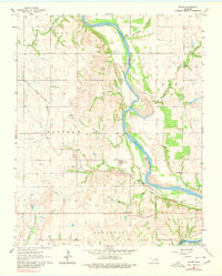
1963 Map of Uncas
USGS Topo · Published 1980About this map
The Arkansas River winds through the heart of this North Central Oklahoma landscape, carving a wide valley between the high ground of Kay and Osage counties. The small settlement of Uncas sits south of the river bend, served by the Atchison Topeka and Santa Fe railroad which cuts diagonally across the prairie. The map reveals an area defined by its watercourses and early industrial activity, with numerous oil wells and gravel pits dotted throughout the terrain. Local history is anchored by landmarks like the Oak Grove Cem and several named creeks including Possum Creek, Wildcat Creek, and Coon Creek. The surveyor's notes indicate that while the topography was mapped in the early 1960s, a 1970s inspection found no major cultural or drainage changes, preserving a view of the rural landscape before the regional transformation brought by later reservoirs.
Find a feature on this map
26 named features on this map. Tap any name to fly to it.
Don’t see what you’re looking for? This feature index may not catch every label — zoom into the map to look around manually.
Map Details
Editions of this 1963 Uncas Map
2 editions found
Other maps of this area

1935 · Kaw
USGS Topo · 1:62,500

1936 · Belford
USGS Topo · 1:62,500

1955 · Enid
USGS Topo · 1:250,000

1958 · Enid
USGS Topo · 1:250,000

1963 · Charley Creek
USGS Topo · 1:24,000

1963 · Uncas
USGS Topo · 1:24,000

1963 · Kaw City NW
USGS Topo · 1:24,000

1964 · Charley Creek NE
USGS Topo · 1:24,000

1964 · Kaw City
USGS Topo · 1:24,000
1964 · Hardy
USGS Topo · 1:24,000