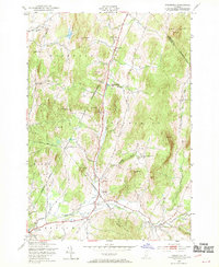
1948 Map of Underhill
USGS Topo · Published 1970About this map
Browns River and its various tributaries, including The Creek and Roaring Brook, carve through the complex terrain of the Green Mountain foothills during the late 1940s. The landscape is defined by its small, specialized school districts, such as the English Settlement Sch and the Irish Settlement Sch, which reflect the ethnic and social history of these rural Vermont neighborhoods. The topography is dominated by numerous high points like Metcalf Hill, Duffy Hill, and Hedgehog Hill, which influenced the placement of farms and early settlements.
Find a feature on this map
41 named features on this map. Tap any name to fly to it.
Don’t see what you’re looking for? This feature index may not catch every label — zoom into the map to look around manually.
Map Details
Editions of this 1948 Underhill Map
4 editions found
Other maps of this area

1906 · Burlington
USGS Topo · 1:62,500

1913 · Milton
USGS Topo · 1:48,000

1915 · Milton
USGS Topo · 1:62,500

1919 · Burlington
USGS Topo · 1:62,500

1921 · Richmond
USGS Topo · 1:48,000

1924 · Camels Hump
USGS Topo · 1:62,500

1925 · Mount Mansfield
USGS Topo · 1:48,000

1927 · Mount Mansfield
USGS Topo · 1:62,500

1944 · Milton
USGS Topo · 1:62,500

1944 · Mount Mansfield
USGS Topo · 1:62,500