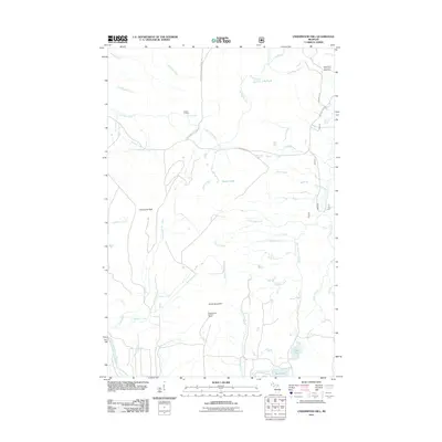
2011 Map of Underwood Hill
USGS Topo · Published 2011About this map
Underwood Hill and the surrounding wilderness of Ontonagon County are depicted in this 2011 survey, centered on the high ground of the Underwood Lookout Tower. The landscape is defined by a dense network of tributaries including Bessemer Creek, Texas Creek, and Canyon Creek, which carve through the terrain toward the Little Carp River and the West Branch Iron River. This area serves as a significant recreational and conservation zone, containing portions of the Porcupine Mtn Wilderness Trl and the remote Section 17 Cabin near Greenstone Falls. Local infrastructure is sparse, limited to seasonal access roads such as S Boundary Rd and Summit Pk Rd, which connect quiet water bodies like Lily Pond, Beaver Lake, and the White Pine Camp and Picnic Area. The map captures the specialized names of the Northwoods, from Salt Pork Creek to Titmouse Creek, illustrating a well-preserved natural corridor.
Find a feature on this map
39 named features on this map. Tap any name to fly to it.
Don’t see what you’re looking for? This feature index may not catch every label — zoom into the map to look around manually.
Map Details
Editions of this 2011 Underwood Hill Map
This is the sole edition of this map. No revisions or reprints were ever made.
Other maps of this area

1956 · Carp River
USGS Topo · 1:62,500

1956 · Bergland
USGS Topo · 1:62,500

1956 · Thomaston
USGS Topo · 1:62,500

1956 · White Pine
USGS Topo · 1:62,500

1958 · Iron River
USGS Topo · 1:250,000

1960 · Iron River
USGS Topo · 1:250,000

1961 · Iron River
USGS Topo · 1:250,000

1967 · Iron River
USGS Topo · 1:250,000

1979 · Ontonagon
USGS Topo · 1:100,000
1980 · Carp River
USGS Topo · 1:25,000