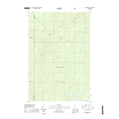
2019 Map of Underwood Hill
USGS Topo · Published 2019About this map
The Porcupine Mountains dominate this landscape within the Ottawa National Forest, where the terrain rises sharply toward Porcupine Peak and Underwood Hill. This 2019 survey documents a wilderness primarily defined by its complex drainage network and recreation infrastructure. The N Country National Scenic Trail winds through the northern half of the quadrangle, crossing numerous waterways such as the Little Carp River and passing landmarks like Greenstone Falls. The southern reaches are characterized by a transition to lower, marshy ground surrounding Bass Lake and the W Br Iron River. For the local historian or outdoorsman, the map detail captures the remote character of Ontonagon County, from the isolated Lily Pond to the secondary forest roads like S Boundary Rd that provide the only vehicle access into this dense timberland.
Find a feature on this map
44 named features on this map. Tap any name to fly to it.
Don’t see what you’re looking for? This feature index may not catch every label — zoom into the map to look around manually.
Map Details
Editions of this 2019 Underwood Hill Map
This is the sole edition of this map. No revisions or reprints were ever made.
Other maps of this area

1956 · Carp River
USGS Topo · 1:62,500

1956 · Bergland
USGS Topo · 1:62,500

1956 · Thomaston
USGS Topo · 1:62,500

1956 · White Pine
USGS Topo · 1:62,500

1958 · Iron River
USGS Topo · 1:250,000

1960 · Iron River
USGS Topo · 1:250,000

1961 · Iron River
USGS Topo · 1:250,000

1967 · Iron River
USGS Topo · 1:250,000

1979 · Ontonagon
USGS Topo · 1:100,000
1980 · Carp River
USGS Topo · 1:25,000