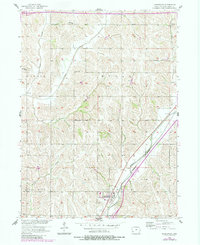
1956 Map of Underwood
USGS Topo · Published 1984About this map
Underwood serves as the central hub of this mid-century rural landscape, situated at the junction of the Burlington Northern railroad and a network of county roads. The map reveals a remarkably dense system of local country schools that once anchored these townships, including Beehive Sch, Porter Sch, Grandview Sch, and Thomas Sch. This pattern reflects the decentralized education system common across Iowa before the height of district consolidation.
Find a feature on this map
32 named features on this map. Tap any name to fly to it.
Don’t see what you’re looking for? This feature index may not catch every label — zoom into the map to look around manually.
Map Details
Editions of this 1956 Underwood Map
2 editions found
Other maps of this area

1893 · Omaha
USGS Topo · 1:62,500

1954 · Omaha
USGS Topo · 1:250,000

1956 · Underwood
USGS Topo · 1:24,000

1956 · Council Bluffs North
USGS Topo · 1:24,000

1956 · Neola
USGS Topo · 1:24,000

1956 · Mc Clelland
USGS Topo · 1:24,000

1957 · Omaha
USGS Topo · 1:250,000

1957 · Taylor
USGS Topo · 1:24,000

1957 · Honey Creek
USGS Topo · 1:24,000

1958 · Omaha
USGS Topo · 1:250,000