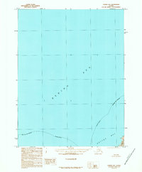
1989 Map of Unimak B-6
USGS Topo · Published 1989About this map
The Bering Sea dominates this maritime survey, illustrating a critical stretch of the Aleutian chain where the northern waters meet the protected reach of Akutan Bay. The map focuses primarily on open water and the administrative limits of the Aleutians East Borough, though the southeastern corner provides a detailed look at the rocky shoreline of Akun Island. Compiled from 1983 aerial photography and edited in 1989, this provisional study reflects the navigational and jurisdictional complexities of the region at a time when precise shoreline mapping was vital for the fishing and transport industries in the Aleutians. The boundary between the sea and the bay is marked as indefinite, capturing the fluid nature of these subarctic coastal environments.
Find a feature on this map
4 named features on this map. Tap any name to fly to it.
Don’t see what you’re looking for? This feature index may not catch every label — zoom into the map to look around manually.
Map Details
Editions of this 1989 Unimak B-6 Map
This is the sole edition of this map. No revisions or reprints were ever made.
Other maps of this area

1951 · Unalaska
USGS Topo · 1:250,000

1951 · Unimak
USGS Topo · 1:250,000

1958 · Unimak
USGS Topo · 1:250,000
1989 · Unimak B-5
USGS Topo · 1:63,360

1989 · Unimak A-6
USGS Topo · 1:63,360
1989 · Unalaska D-1
USGS Topo · 1:63,360
1989 · Unimak A-5
USGS Topo · 1:63,360
2020 · Unalaska D-1 NE
USGS Topo · 1:25,000
2020 · Unimak B-5 SW
USGS Topo · 1:25,000
2020 · Unimak B-6 SE
USGS Topo · 1:25,000