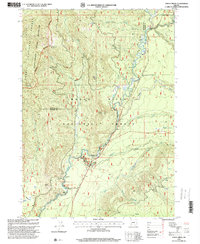
1997 Map of Union Creek
USGS Topo · Published 2000About this map
The Rogue River carves a dramatic path through the Cascades in this late 20th-century survey of the Rogue River National Forest. The map focuses on the geological and recreational corridor where the river disappears into the volcanic conduits of the Natural Bridge, a significant natural landmark near the small settlement of Union Creek. The hydrology of the area is further defined by the Rogue River Gorge and the convergence of several drainages, including Castle Creek and Prairie Creek. High-elevation landmarks like Anderson Mountain, Wolf Peak, and Mount Stella border the deep river valley, while the Rogue-Umpqua Scenic Byway provides the primary transit route through this timbered landscape. The inclusion of the Rogue Umpqua Divide Wilderness boundary reflects the area's transition toward protected forest management during this era.
Find a feature on this map
33 named features on this map. Tap any name to fly to it.
Don’t see what you’re looking for? This feature index may not catch every label — zoom into the map to look around manually.
Map Details
Editions of this 1997 Union Creek Map
This is the sole edition of this map. No revisions or reprints were ever made.
Other maps of this area

1891 · Ashland
USGS Topo · 1:250,000

1893 · Ashland
USGS Topo · 1:250,000

1897 · Ashland
USGS Topo · 1:250,000

1917 · Diamond Lake
USGS Topo · 1:125,000

1944 · Abbott Butte
USGS Topo · 1:62,500

1947 · Abbott Butte
USGS Topo · 1:62,500

1955 · Quartz Mtn
USGS Topo · 1:62,500

1955 · Medford
USGS Topo · 1:250,000

1956 · Garwood Butte
USGS Topo · 1:62,500

1956 · Prospect
USGS Topo · 1:62,500