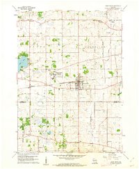
1960 Map of Union Grove
USGS Topo · Published 1962About this map
The village of Union Grove serves as the central hub of this 1960 survey, situated at the intersection of a developing road network and the Chicago Milwaukee St Paul and Pacific railroad. The landscape transition is evident where the agricultural tracts of Yorkville and Brighton meet institutional and industrial sites. Most notable is the sprawling Richard Bong Air Force Base (Abandoned) in the southwest, reflecting a significant moment in Cold War era land use.
Find a feature on this map
35 named features on this map. Tap any name to fly to it.
Don’t see what you’re looking for? This feature index may not catch every label — zoom into the map to look around manually.
Map Details
Editions of this 1960 Union Grove Map
2 editions found
Other maps of this area

1891 · Bayview
USGS Topo · 1:62,500

1891 · Muskego
USGS Topo · 1:62,500

1892 · Racine
USGS Topo · 1:62,500

1893 · Silver Lake
USGS Topo · 1:62,500

1901 · Bayview
USGS Topo · 1:62,500

1901 · Muskego
USGS Topo · 1:62,500

1905 · Racine
USGS Topo · 1:62,500

1906 · Silver Lake
USGS Topo · 1:62,500

1954 · Rockford
USGS Topo · 1:250,000

1955 · Rockford
USGS Topo · 1:250,000