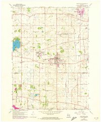
1960 Map of Union Grove
USGS Topo · Published 1973About this map
The massive footprint of the Richard Bong Air Force Base (Abandoned) dominates the western edge of this agricultural landscape in Racine and Kenosha Counties. The base, which was intended as a major Cold War installation before its construction was abruptly halted, stands in contrast to the established village of Union Grove, which serves as a central hub for the surrounding townships of Dover, Yorkville, Brighton, and Paris. The presence of the Chicago Milwaukee St Paul and Pacific railroad bisects the region, facilitating the movement of goods between rural settlements like Kansasville, Beaumont, and Yorkville.
Find a feature on this map
39 named features on this map. Tap any name to fly to it.
Don’t see what you’re looking for? This feature index may not catch every label — zoom into the map to look around manually.
Map Details
Editions of this 1960 Union Grove Map
2 editions found
Other maps of this area

1891 · Bayview
USGS Topo · 1:62,500

1891 · Muskego
USGS Topo · 1:62,500

1892 · Racine
USGS Topo · 1:62,500

1893 · Silver Lake
USGS Topo · 1:62,500

1901 · Bayview
USGS Topo · 1:62,500

1901 · Muskego
USGS Topo · 1:62,500

1905 · Racine
USGS Topo · 1:62,500

1906 · Silver Lake
USGS Topo · 1:62,500

1954 · Rockford
USGS Topo · 1:250,000

1955 · Rockford
USGS Topo · 1:250,000