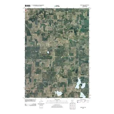
2010 Map of Union Hill
USGS Topo · Published 2010About this map
Union Hill serves as the focal point of this rural Scott County landscape, situated at the intersection of local routes that partition the agricultural terrain into a precise grid. The area is defined by its deep-rooted German heritage, evidenced by the presence of the Friedens Evangelical Lutheran Church and its associated Friedens Evangelical Lutheran Church Cemetery. These spiritual centers, along with the Saint Johns Cemetery and the Pomeranian Cemetery, offer significant markers for genealogical research in this part of Minnesota.
Find a feature on this map
49 named features on this map. Tap any name to fly to it.
Don’t see what you’re looking for? This feature index may not catch every label — zoom into the map to look around manually.
Map Details
Editions of this 2010 Union Hill Map
This is the sole edition of this map. No revisions or reprints were ever made.
Other maps of this area

1953 · Saint Paul
USGS Topo · 1:250,000

1957 · Belle Plaine
USGS Topo · 1:62,500

1957 · New Prague
USGS Topo · 1:62,500

1959 · Saint Paul
USGS Topo · 1:250,000

1965 · St Thomas
USGS Topo · 1:24,000

1966 · Montgomery
USGS Topo · 1:24,000

1966 · Le Center
USGS Topo · 1:24,000
1981 · New Prague
USGS Topo · 1:24,000
1981 · Jordan West
USGS Topo · 1:24,000
1981 · Belle Plaine South
USGS Topo · 1:24,000