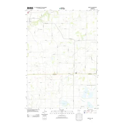
2013 Map of Union Hill
USGS Topo · Published 2013About this map
The settlement of Union Hill straddles the boundary between Scott Co and Le Sueur Co, serving as a central point in this agricultural landscape. This portion of southern Minnesota is defined by its glacial heritage, featuring a complex network of wetlands and lakes such as Graham Lake, Renneberg Lake, and Tietz Lake. Drainage is managed by the winding paths of the W Br Raven Stream and E Br Raven Stream, which cut through the local topography. For those researching family history, the map identifies several significant burial sites, including Saint Johns Cem near the town center and the Friedens Evangelical Lutheran Church Cem to the southeast. The area is gridded by a dense network of named local roads and boulevards, reflecting the established land divisions and rural residency patterns of the early twenty-first century.
Find a feature on this map
45 named features on this map. Tap any name to fly to it.
Don’t see what you’re looking for? This feature index may not catch every label — zoom into the map to look around manually.
Map Details
Editions of this 2013 Union Hill Map
This is the sole edition of this map. No revisions or reprints were ever made.
Other maps of this area

1953 · Saint Paul
USGS Topo · 1:250,000

1957 · Belle Plaine
USGS Topo · 1:62,500

1957 · New Prague
USGS Topo · 1:62,500

1959 · Saint Paul
USGS Topo · 1:250,000

1965 · St Thomas
USGS Topo · 1:24,000

1966 · Montgomery
USGS Topo · 1:24,000

1966 · Le Center
USGS Topo · 1:24,000
1981 · New Prague
USGS Topo · 1:24,000
1981 · Jordan West
USGS Topo · 1:24,000
1981 · Belle Plaine South
USGS Topo · 1:24,000