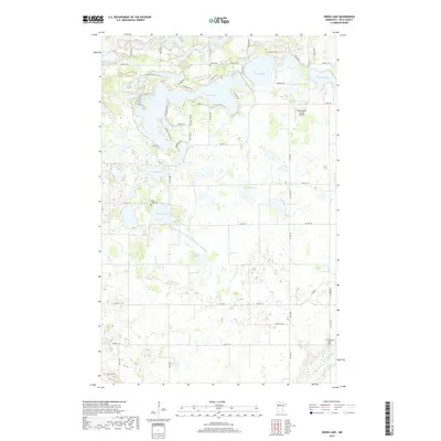
2019 Map of Union Lake
USGS Topo · Published 2019About this map
Union Lake and Lake Sarah dominate this portion of Polk County, where the landscape is defined by a dense network of glacial basins and water management systems. The complex drainage patterns of the region are evidenced by the long reach of County Ditch Number One Hundred Thirtythree, which cuts across the central townships to regulate the water levels of the surrounding prairies and wetlands. The human history of the area is well-preserved through several rural burial grounds, including Bailey Cem and Lima Cem, which stand alongside the namesake Union Lake Cem. Small-scale aviation is represented by the Hemmingsen Private Airport in the northeast, while the southern boundary is marked by the winding course of the Sand Hill River. Residential development is concentrated along the shorelines, particularly near N Shore Dr SE and Sunset Shores Rd SE.
Find a feature on this map
60 named features on this map. Tap any name to fly to it.
Don’t see what you’re looking for? This feature index may not catch every label — zoom into the map to look around manually.
Map Details
Editions of this 2019 Union Lake Map
This is the sole edition of this map. No revisions or reprints were ever made.
Other maps of this area
1919 · Valley
USGS Topo · 1:62,500
1952 · Grand Forks
USGS Topo · 1:250,000

1954 · Bemidji
USGS Topo · 1:250,000
1956 · Grand Forks
USGS Topo · 1:250,000

1957 · Bemidji
USGS Topo · 1:250,000

1958 · Bemidji
USGS Topo · 1:250,000
1966 · Grand Forks
USGS Topo · 1:250,000
1966 · Halverson Lake
USGS Topo · 1:24,000
1966 · Union Lake
USGS Topo · 1:24,000
1966 · Ranum
USGS Topo · 1:24,000