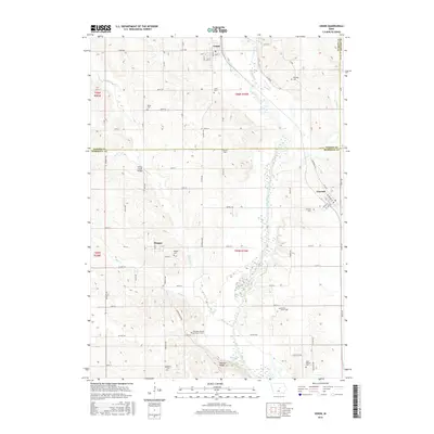
2015 Map of Union
USGS Topo · Published 2015About this map
The Iowa River cuts a winding path through the heart of this central Iowa landscape, dividing the fertile upland plains of Hardin and Marshall counties. The settlement of Union sits at the northern edge, while Liscomb and Bangor anchor the southeastern and southwestern quadrants, respectively. This 2015 survey reveals a terrain defined by agricultural grid lines interrupted by the riparian corridor of the river and its tributaries, including Honey Cr and Mud Cr.
Find a feature on this map
55 named features on this map. Tap any name to fly to it.
Don’t see what you’re looking for? This feature index may not catch every label — zoom into the map to look around manually.
Map Details
Editions of this 2015 Union Map
This is the sole edition of this map. No revisions or reprints were ever made.
Other maps of this area

1954 · Waterloo
USGS Topo · 1:250,000

1955 · Waterloo
USGS Topo · 1:250,000

1960 · Marshalltown
USGS Topo · 1:24,000

1960 · Marshalltown
USGS Topo · 1:62,500

1960 · Conrad West
USGS Topo · 1:24,000

1975 · State Center NW
USGS Topo · 1:24,000

1975 · State Center
USGS Topo · 1:24,000

1975 · Union
USGS Topo · 1:24,000
1975 · La Moille
USGS Topo · 1:24,000

1979 · New Providence
USGS Topo · 1:24,000