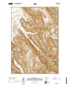
2020 Map of Union
USGS Topo · Published 2020About this map
The Union townsite occupies the western edge of this 2020 survey, where the residential grid meets the expansive Grande Ronde Valley. This area is defined by a sophisticated network of water management, including the Catherine Cr Highline Canal and Prescott Ditch, which redirect flow from Catherine Cr to support the local agriculture. The topography rises sharply east of town into the foothills of the Wallowa Mountains, revealing a landscape of steep drainages like Pyles Canyon and high points such as Clark Mtn.
Find a feature on this map
48 named features on this map. Tap any name to fly to it.
Don’t see what you’re looking for? This feature index may not catch every label — zoom into the map to look around manually.
Map Details
Editions of this 2020 Union Map
This is the sole edition of this map. No revisions or reprints were ever made.
Other maps of this area

1906 · Telocaset
USGS Topo · 1:125,000

1955 · Grangeville
USGS Topo · 1:250,000

1959 · Grangeville
USGS Topo · 1:250,000

1965 · Conley
USGS Topo · 1:24,000

1965 · Union
USGS Topo · 1:24,000

1965 · Medical Springs
USGS Topo · 1:24,000

1965 · Cove
USGS Topo · 1:24,000
1965 · North Powder
USGS Topo · 1:24,000

1965 · Little Catherine Creek
USGS Topo · 1:24,000
1965 · Telocaset
USGS Topo · 1:24,000