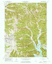
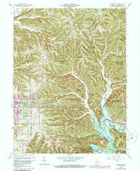
1966 Map of Unionville
USGS Topo · Published 1968About this map
Benton and Perry townships meet in this mid-1960s survey of the wooded ridges north and east of Bloomington. The landscape is dominated by the sprawling boundaries of Morgan-Monroe State Forest and the Hoosier National Forest, protecting much of the drainage for Monroe Lake and Lake Lemon. While the university town expands eastward with the College Mall Shopping Center and new residential developments like Eastern Heights and Hoosier Acres, the rural character of the county remains intact through settlements such as Unionville and New Unionville. Local heritage is preserved at landmark sites including the Locust Grove Cem and Little Union Cem, alongside numerous country churches. The map documents a period of significant hydrological transition as the North Fork Salt Creek flows into the newly formed Monroe Lake, illustrating the impact of 20th-century water management on the Indiana backcountry.
Find a feature on this map
63 named features on this map. Tap any name to fly to it.
Don’t see what you’re looking for? This feature index may not catch every label — zoom into the map to look around manually.
Map Details
Editions of this 1966 Unionville Map
5 editions found
Other maps of this area

1908 · Bloomington
USGS Topo · 1:48,000

1910 · Bloomington
USGS Topo · 1:62,500

1942 · Franklin
USGS Topo · 1:125,000

1946 · Belmont
USGS Topo · 1:24,000

1947 · Allens Creek
USGS Topo · 1:24,000

1947 · Unionville
USGS Topo · 1:24,000

1947 · Elkinsville
USGS Topo · 1:24,000

1948 · Hindustan
USGS Topo · 1:24,000

1948 · Morgantown
USGS Topo · 1:24,000

1950 · Belmont
USGS Topo · 1:24,000