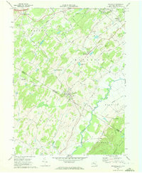
1969 Map of Unionville
USGS Topo · Published 1972About this map
Unionville and the surrounding agricultural valleys straddle the border between Orange County and Sussex County during the late 1960s. This landscape is defined by the winding course of the Wallkill River and its tributaries, including Rutgers Creek and Indigot Creek, which supported early industry at sites like Waterloo Mills. The map details a transition from traditional farming to a modernizing rural infrastructure, evident in the mix of old turnpikes and newer pipelines crossing the terrain.
Find a feature on this map
56 named features on this map. Tap any name to fly to it.
Don’t see what you’re looking for? This feature index may not catch every label — zoom into the map to look around manually.
Map Details
Editions of this 1969 Unionville Map
Other maps of this area

1888 · Franklin
USGS Topo · 1:62,500

1891 · Greenwood Lake
USGS Topo · 1:62,500

1893 · Greenwood Lake
USGS Topo · 1:62,500

1894 · Franklin
USGS Topo · 1:62,500

1897 · Franklin
USGS Topo · 1:62,500

1903 · Franklin Furnace
USGS Topo · 1:62,500

1903 · Greenwood Lake
USGS Topo · 1:62,500

1906 · Port Jervis
USGS Topo · 1:62,500

1906 · Goshen
USGS Topo · 1:62,500

1908 · Goshen
USGS Topo · 1:62,500