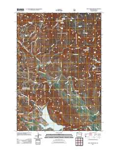
2011 Map of Unity Reservoir
USGS Topo · Published 2011About this map
Martins Mill and the King Ranch anchor this high-elevation landscape in Baker County, where water management is the central theme of the terrain. The southern portion of the map is dominated by the Unity Reservoir, into which the Middle Fork Burnt River and North Fork Burnt River flow. A network of man-made irrigation features, including Thompson Ditch and the China Creek Ditch, illustrates the historical effort to divert snowmelt from the surrounding peaks to support local agriculture and livestock. In the eastern reaches, Big Flat provides a level expanse for the Big Flat Cemetery, while the surrounding heights are marked by distinctive landmarks like King Mountain and Cottonwood Buttes. The abundance of named springs, such as China Creek Spring and Badger Hole Spring, highlights the critical importance of reliable water sources in this high-desert environment.
Find a feature on this map
51 named features on this map. Tap any name to fly to it.
Don’t see what you’re looking for? This feature index may not catch every label — zoom into the map to look around manually.
Map Details
Editions of this 2011 Unity Reservoir Map
This is the sole edition of this map. No revisions or reprints were ever made.
Other maps of this area

1901 · Sumpter
USGS Topo · 1:125,000

1908 · Ironside Mountain
USGS Topo · 1:125,000

1955 · Canyon City
USGS Topo · 1:250,000

1959 · Canyon City
USGS Topo · 1:250,000

1961 · Whitney
USGS Topo · 1:24,000
1972 · Hereford
USGS Topo · 1:24,000
1972 · Unity
USGS Topo · 1:24,000
1972 · Phillips Lake
USGS Topo · 1:24,000
1972 · Sumpter
USGS Topo · 1:24,000
1972 · Beaverdam Creek
USGS Topo · 1:24,000