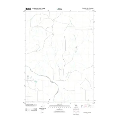
2011 Map of University Lake
USGS Topo · Published 2011About this map
Wind Springs Creek and Spottedtail Creek weave through this section of the Nebraska panhandle, a landscape defined by expansive cattle operations and vital irrigation infrastructure. The 2011 survey reveals the critical role of water management in this arid region, most notably through the Interstate Canal and its associated watercourses like Lateral 21 Main that feed the local ranching economy. Named ranching sites such as Wind Springs Ranch, F-X Ranch, and Point Option Ranch are established across the terrain, alongside specialized agricultural landmarks like the High Plains Feed Yard. Near the western edge, University Lake and distinctive geographical markers such as The Horseshoe and The Hat provide focal points within the broad cattle country of Sioux County.
Find a feature on this map
16 named features on this map. Tap any name to fly to it.
Don’t see what you’re looking for? This feature index may not catch every label — zoom into the map to look around manually.
Map Details
Editions of this 2011 University Lake Map
This is the sole edition of this map. No revisions or reprints were ever made.
Other maps of this area

1898 · Scotts Bluff
USGS Topo · 1:125,000

1899 · Whistle Creek
USGS Topo · 1:125,000

1954 · Scottsbluff
USGS Topo · 1:250,000

1955 · Alliance
USGS Topo · 1:250,000

1957 · Alliance
USGS Topo · 1:250,000

1958 · Alliance
USGS Topo · 1:250,000

1958 · Scottsbluff
USGS Topo · 1:250,000

1963 · Mitchell
USGS Topo · 1:24,000

1963 · Scottsbluff North
USGS Topo · 1:24,000
1963 · Erdman Ranch
USGS Topo · 1:24,000