
1949 Map of Upatoi
USGS Topo · Published 1949About this map
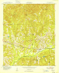
The Fort Benning Military Reservation boundary dominates the southern landscape of this 1949 survey, illustrating the significant military footprint in the region shortly after World War II. The terrain is defined by a dense network of waterways including Upatoi Creek, Kendall Creek, and the Fox River, which drain the undulating hills at the junction of Muscogee, Talbot, and Chattahoochee counties. The Central of Georgia railroad provides the primary east-west transportation corridor, connecting the small settlements of Upatoi and Box Springs. Local rural life is anchored by landmarks like Mt Carmel Church and several unnamed cemeteries, while Kings Mill Pond and Mobleys Pond suggest the importance of local water resources and milling history. The map also records civil infrastructure such as the water tower near Box Springs, providing a detailed look at the rural infrastructure of the late 1940s.
Find a feature on this map
24 named features on this map. Tap any name to fly to it.
Don’t see what you’re looking for? This feature index may not catch every label — zoom into the map to look around manually.
Map Details
Editions of this 1949 Upatoi Map
2 editions found
Other maps of this area

1907 · Talbotton
USGS Topo · 1:125,000

1908 · Columbus
USGS Topo · 1:62,500

1929 · Columbus
USGS Topo · 1:48,000

1947 · Columbus
USGS Topo · 1:62,500

1949 · Midland
USGS Topo · 1:24,000

1949 · Ochillee
USGS Topo · 1:24,000

1949 · Buena Vista NW
USGS Topo · 1:24,000

1950 · Talbotton
USGS Topo · 1:24,000

1950 · Geneva
USGS Topo · 1:24,000

1950 · Waverly Hall
USGS Topo · 1:24,000