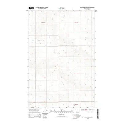
2014 Map of Upper Cracker Box School
USGS Topo · Published 2014About this map
The Upper Cracker Box School serves as a lone landmark in this sparsely settled corner of Dawson County. Located near the intersection of Road 229 and a network of unimproved trails, the schoolhouse site illustrates the importance of centralized community hubs in the vast ranching landscapes of eastern Montana. The terrain is defined by the complex drainage systems of Clear Creek, including its north branch, N Br Clear Creek, and the eastward-flowing Sand Creek. These watercourses carve out a series of ridges and coulees across the township boundaries of T15N and T16N. Aside from the occasional county road like Cr-238, the map reveals a rugged, open environment where transportation follows the natural contours of the land, reflecting the enduring rural character of the region in the early 21st century.
Find a feature on this map
13 named features on this map. Tap any name to fly to it.
Don’t see what you’re looking for? This feature index may not catch every label — zoom into the map to look around manually.
Map Details
Editions of this 2014 Upper Cracker Box School Map
This is the sole edition of this map. No revisions or reprints were ever made.
Other maps of this area

1909 · Glendive
USGS Topo · 1:250,000

1953 · Miles City
USGS Topo · 1:250,000

1954 · Glendive
USGS Topo · 1:250,000

1957 · Miles City
USGS Topo · 1:250,000

1957 · Glendive
USGS Topo · 1:250,000

1958 · Miles City
USGS Topo · 1:250,000

1958 · Glendive
USGS Topo · 1:250,000
1967 · Marsh
USGS Topo · 1:24,000
1967 · Fallon NE
USGS Topo · 1:24,000
1972 · Hendrickson Coulee
USGS Topo · 1:24,000