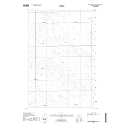
2020 Map of Upper Cracker Box School
USGS Topo · Published 2020About this map
Upper Cracker Box School (Historical) stands as a primary historical landmark in this corner of Dawson County, reflecting the early educational framework of rural Montana. This 2020 edition documents the drainage patterns and township divisions across a landscape defined by seasonal watercourses. The drainage of Cracker Box Cr and its N Fork Cracker Box Cr branch dominate the southern half of the map, while the northern sections are carved by Clear Cr and N Br Clear Cr. The presence of these named creeks alongside the historical school site offers a clear view of how early homesteading and social infrastructure were tethered to the local hydrography. The terrain is further navigated by county routes such as Rd 238 and Rd 229, providing a modern grid over the traditional land divisions of T15N and T16N.
Find a feature on this map
14 named features on this map. Tap any name to fly to it.
Don’t see what you’re looking for? This feature index may not catch every label — zoom into the map to look around manually.
Map Details
Editions of this 2020 Upper Cracker Box School Map
This is the sole edition of this map. No revisions or reprints were ever made.
Other maps of this area

1909 · Glendive
USGS Topo · 1:250,000

1953 · Miles City
USGS Topo · 1:250,000

1954 · Glendive
USGS Topo · 1:250,000

1957 · Miles City
USGS Topo · 1:250,000

1957 · Glendive
USGS Topo · 1:250,000

1958 · Miles City
USGS Topo · 1:250,000

1958 · Glendive
USGS Topo · 1:250,000
1967 · Marsh
USGS Topo · 1:24,000
1967 · Fallon NE
USGS Topo · 1:24,000
1972 · Hendrickson Coulee
USGS Topo · 1:24,000