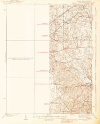
1938 Map of Upper Marlboro
USGS Topo · Published 1938About this map
Upper Marlboro serves as the focal point of this 1930s landscape, illustrating a transition between agrarian Prince George's County and the expanding influence of the capital. The map details an era when rail transport was still vital, featuring the Pennsylvania RR and the W B and A El RR cutting through rural districts like Lanham and Glenn Dale. Local community life is anchored by numerous small landmarks, including the St Barnabas Ch and Collington Sch, while the network of water ways such as Western Branch and Collington Branch define the physical geography of the various numbered districts. Settlements like Rosaryville, Mellwood, and Seabrook appear as distinct clusters connected by the Defense Highway and Central Avenue, reflecting the early 20th-century road infrastructure that preceded modern suburban sprawl.
Find a feature on this map
65 named features on this map. Tap any name to fly to it.
Don’t see what you’re looking for? This feature index may not catch every label — zoom into the map to look around manually.
Map Details
Editions of this 1938 Upper Marlboro Map
3 editions found
Other maps of this area

1890 · Mt. Vernon
USGS Topo · 1:125,000

1891 · Mt. Vernon
USGS Topo · 1:125,000

1892 · Laurel
USGS Topo · 1:62,500

1892 · Prince Frederick
USGS Topo · 1:62,500

1892 · Brandywine
USGS Topo · 1:62,500

1892 · Owensville
USGS Topo · 1:62,500

1893 · Frederick
USGS Topo · 1:125,000

1894 · Laurel
USGS Topo · 1:62,500

1894 · Frederick
USGS Topo · 1:125,000

1894 · Relay
USGS Topo · 1:62,500