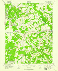
1957 Map of Upper Marlboro
USGS Topo · Published 1958About this map
Upper Marlboro serves as the focal point of this late 1950s survey of central Prince George's County, where the transition from traditional Maryland tobacco farming to Cold War military expansion is clearly visible. The University of Maryland Tobacco Experimental Farm and large rural estates like Mt Airy (Curtis Birthplace) sit alongside the sprawling Andrews Air Force Base, which occupies a significant portion of the western landscape.
Find a feature on this map
63 named features on this map. Tap any name to fly to it.
Don’t see what you’re looking for? This feature index may not catch every label — zoom into the map to look around manually.
Map Details
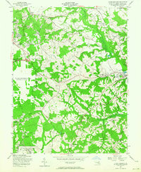
Editions of this 1957 Upper Marlboro Map
2 editions found
Other maps of this area

1892 · Prince Frederick
USGS Topo · 1:62,500

1892 · Brandywine
USGS Topo · 1:62,500

1892 · Owensville
USGS Topo · 1:62,500

1895 · Prince Frederick
USGS Topo · 1:62,500

1895 · Brandywine
USGS Topo · 1:62,500

1895 · Owensville
USGS Topo · 1:62,500

1899 · Patuxent
USGS Topo · 1:125,000

1900 · Washington
USGS Topo · 1:62,500

1901 · Prince Frederick
USGS Topo · 1:62,500

1905 · Owensville
USGS Topo · 1:62,500