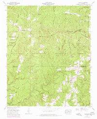
1960 Map of Upshaw
USGS Topo · Published 1977About this map
Brindley Mountain and the Tennessee Valley Divide dominate the topography of this portion of northern Alabama, where the headwaters of several drainages begin their descent toward the Tennessee and Black Warrior basins. The landscape is heavily forested, primarily within the William B Bankhead National Forest, yet a network of rural settlements persists along the ridges. The community of Upshaw serves as a local node, supported by institutions like the Penn School and Corinth Cem.
Find a feature on this map
65 named features on this map. Tap any name to fly to it.
Don’t see what you’re looking for? This feature index may not catch every label — zoom into the map to look around manually.
Map Details
Editions of this 1960 Upshaw Map
Other maps of this area

1935 · Moulton
USGS Topo · 1:24,000

1935 · Upshaw
USGS Topo · 1:24,000

1935 · Danville
USGS Topo · 1:48,000

1935 · Oakville
USGS Topo · 1:24,000

1936 · Mc Kendry
USGS Topo · 1:24,000

1936 · Moulton
USGS Topo · 1:48,000

1936 · Stroups Crossroads
USGS Topo · 1:24,000

1938 · Danville
USGS Topo · 1:62,500

1940 · Mt Hope
USGS Topo · 1:62,500

1956 · Gadsden
USGS Topo · 1:250,000