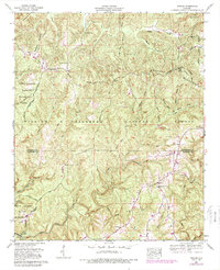
1960 Map of Upshaw
USGS Topo · Published 1989About this map
Brindley Mountain dominates the high ground in this 1960 survey, serving as a backdrop for the small community of Upshaw and the surrounding timberlands. The landscape is defined by the Tennessee Valley Divide, which separates the north-flowing waters like West Flint Creek and Wiggins Hollow from the southern drainages of the Black Warrior Wildlife Management Area. Numerous family-named landmarks and rural institutions are scattered through the valleys, including Lindsay Hall Ch and the Basham Lookout Tower standing watch over the William B Bankhead National Forest. This document is particularly valuable for genealogists, as it meticulously records small rural burial grounds such as Asherbracker Cem, Simms Cem, and Friendship Cem, offering a detailed view of the settlement pattern along the county line.
Find a feature on this map
54 named features on this map. Tap any name to fly to it.
Don’t see what you’re looking for? This feature index may not catch every label — zoom into the map to look around manually.
Map Details
Editions of this 1960 Upshaw Map
Other maps of this area

1935 · Moulton
USGS Topo · 1:24,000

1935 · Upshaw
USGS Topo · 1:24,000

1935 · Danville
USGS Topo · 1:48,000

1935 · Oakville
USGS Topo · 1:24,000

1936 · Mc Kendry
USGS Topo · 1:24,000

1936 · Moulton
USGS Topo · 1:48,000

1936 · Stroups Crossroads
USGS Topo · 1:24,000

1938 · Danville
USGS Topo · 1:62,500

1940 · Mt Hope
USGS Topo · 1:62,500

1956 · Gadsden
USGS Topo · 1:250,000