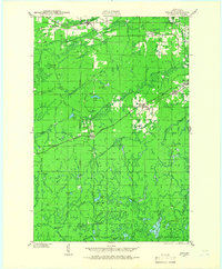
1940 Map of Upson
USGS Topo · Published 1966About this map
Iron County mining and timber landscapes are defined here by a dense network of early 20th-century rail lines, including the Chicago and Northwestern and the Minneapolis St Paul and Sault Ste Marie. The settlement of Iron Belt serves as a focal point near Hillside Cem, while further south, the remote character of the woods is evidenced by logging-era outposts like Melver Camp, Kerstein Camp, and Le Clair Camp.
Find a feature on this map
61 named features on this map. Tap any name to fly to it.
Don’t see what you’re looking for? This feature index may not catch every label — zoom into the map to look around manually.
Map Details
Editions of this 1940 Upson Map
2 editions found
Other maps of this area

1940 · Mercer
USGS Topo · 1:48,000

1940 · Butternut
USGS Topo · 1:48,000

1940 · Upson
USGS Topo · 1:48,000

1942 · Glidden
USGS Topo · 1:48,000

1942 · Mellen
USGS Topo · 1:48,000

1943 · Little Girls Point
USGS Topo · 1:24,000

1943 · Upson
USGS Topo · 1:48,000

1943 · Ironwood
USGS Topo · 1:48,000

1943 · Little Girl Point
USGS Topo · 1:48,000

1943 · Odanah
USGS Topo · 1:48,000