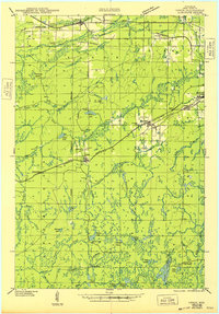
1943 Map of Upson
USGS Topo · Published 1948About this map
Iron County's northern forests and mining district are captured here in the early 1940s, a landscape defined by the convergence of heavy industry and timber harvesting. Settled nodes like Iron Belt and Montreal reflect the region's mineral heritage, while specialized worker outposts such as Melver Camp, Kerstein Camp, and La Clair Camp are situated deep in the timberlands along the Lumber Railroad. The terrain is deeply hydrological, with the Montreal River and Potato River draining a complex system of marshes and lakes, including Weber Lake and Island Lake.
Find a feature on this map
61 named features on this map. Tap any name to fly to it.
Don’t see what you’re looking for? This feature index may not catch every label — zoom into the map to look around manually.
Map Details
Editions of this 1943 Upson Map
2 editions found
Other maps of this area

1940 · Mercer
USGS Topo · 1:48,000

1940 · Butternut
USGS Topo · 1:48,000

1940 · Upson
USGS Topo · 1:48,000

1942 · Glidden
USGS Topo · 1:48,000

1942 · Mellen
USGS Topo · 1:48,000

1943 · Little Girls Point
USGS Topo · 1:24,000

1943 · Upson
USGS Topo · 1:48,000

1943 · Ironwood
USGS Topo · 1:48,000

1943 · Little Girl Point
USGS Topo · 1:48,000

1943 · Odanah
USGS Topo · 1:48,000