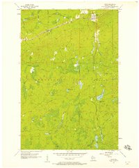
1956 Map of Upson
USGS Topo · Published 1957About this map
The Potato River and its numerous tributaries dominate this mid-century survey of the Iron County landscape. The community of Upson sits at the northern edge, situated where the Minneapolis St Paul and Sault Ste Marie railroad tracks cross the river. Further west along the line, the small settlement of Rouse marks another point of human activity within the dense network of wetlands and creeks.
Find a feature on this map
21 named features on this map. Tap any name to fly to it.
Don’t see what you’re looking for? This feature index may not catch every label — zoom into the map to look around manually.
Map Details
Editions of this 1956 Upson Map
2 editions found
Other maps of this area

1940 · Butternut
USGS Topo · 1:48,000

1940 · Upson
USGS Topo · 1:48,000

1942 · Glidden
USGS Topo · 1:48,000

1942 · Mellen
USGS Topo · 1:48,000

1943 · Upson
USGS Topo · 1:48,000

1945 · Glidden
USGS Topo · 1:48,000

1945 · Mellen
USGS Topo · 1:48,000

1947 · Butternut
USGS Topo · 1:48,000

1950 · Butternut
USGS Topo · 1:48,000

1953 · Ashland
USGS Topo · 1:250,000