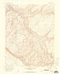
1960 Map of Uravan
USGS Topo · Published 1961About this map
The Uravan company town and its extensive uranium mining infrastructure dominate this 1960 revision, where the San Miguel River cuts through the high desert of Montrose County. The landscape is a map of Cold War industrial activity, specifically centered on the extraction and processing of carnotite ores. Massive Tailings Ponds and piles sit adjacent to the settlement, while the surrounding mesas are perforated by numerous operations such as the Rock Raven Mine, Black Dinah Mine, and Club Mines. Transportation follows the canyon floors and the rim via the Long Park Road and various truck trails. To the south, the terrain descends into the distinctive geomorphology of Paradox Valley and East Paradox Creek, illustrating the complex geological transition from the Spring Creek mesa lands to the deep incisions of Hieroglyphic Canyon.
Find a feature on this map
36 named features on this map. Tap any name to fly to it.
Don’t see what you’re looking for? This feature index may not catch every label — zoom into the map to look around manually.
Map Details
Editions of this 1960 Uravan Map
4 editions found
Other maps of this area

1916 · Paradox Valley
USGS Topo · 1:125,000

1922 · Paradox Valley
USGS Topo · 1:125,000

1948 · Bull Canyon
USGS Topo · 1:24,000

1948 · Uravan
USGS Topo · 1:24,000

1948 · Naturita NW
USGS Topo · 1:24,000

1949 · Bull Canyon
USGS Topo · 1:24,000

1949 · Davis Mesa
USGS Topo · 1:24,000

1949 · Uravan
USGS Topo · 1:24,000

1949 · Naturita NW
USGS Topo · 1:24,000

1949 · Atkinson Creek
USGS Topo · 1:24,000