1985 Map of Utica
USGS Topo · Published 1994About this map
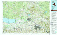
Utica and Rome anchor this industrial and agricultural corridor as it appeared in the mid-1980s, where the Mohawk River and the N.Y. State Thruway serve as the primary arteries of New York's central valley. The landscape is defined by the transition from the flatlands around Oneida Lake to the rising elevations of the Adirondack Park and the Tug Hill plateau. This era shows the region at a point of high utility, featuring the active Griffiss Air Force Base and the collegiate grounds of Hamilton College and Colgate University. Cultural and recreational centers are well-established, with Verona Beach State Park on the lakeshore and Delta Lake State Park providing water management and leisure north of Rome. The intricate network of smaller creeks, such as Sauquoit Creek and Oriskany Creek, traces the historical path of settlement into the surrounding hills.
Find a feature on this map
261 named features on this map. Tap any name to fly to it.
Don’t see what you’re looking for? This feature index may not catch every label — zoom into the map to look around manually.
Map Details
Editions of this 1985 Utica Map
2 editions found

Other maps of this area

1895 · Chittenango
USGS Topo · 1:62,500

1895 · Oriskany
USGS Topo · 1:62,500

1895 · Pulaski
USGS Topo · 1:62,500

1895 · Syracuse
USGS Topo · 1:62,500

1895 · Oneida
USGS Topo · 1:62,500

1897 · Cazenovia
USGS Topo · 1:62,500

1897 · Remsen
USGS Topo · 1:62,500

1898 · Oneida
USGS Topo · 1:62,500

1898 · Syracuse
USGS Topo · 1:62,500

1898 · Chittenango
USGS Topo · 1:62,500