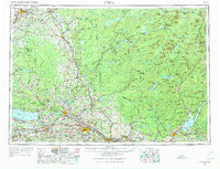
1962 Map of Utica
USGS Topo · Published 1974About this map
Utica and Rome anchor the industrial and transit corridor of the Mohawk Valley in this early 1960s survey. The landscape is defined by the sharp transition from the bustling New York State Thruway and the New York Central rail lines to the rising elevations of the Adirondack Mountains. In Rome, the expansive footprint of Griffiss AFB represents the era's Cold War military presence, while the northern half of the map is dominated by the protected wilderness of Adirondack State Park. Significant water bodies like Oneida Lake and Great Sacandaga Lake serve as recreational hubs, flanked by Verona Beach State Park. To the north, the Black River carves through the landscape near Tug Hill, passing through timber and paper mill towns like Carthage and Lowville. Smaller industrial details, such as a specialized Open pit mine (Garnet) near the eastern edge, highlight the region's diverse mineral resources.
Find a feature on this map
40 named features on this map. Tap any name to fly to it.
Don’t see what you’re looking for? This feature index may not catch every label — zoom into the map to look around manually.
Map Details
Editions of this 1962 Utica Map
3 editions found

Other maps of this area

1893 · Schenectady
USGS Topo · 1:62,500

1893 · Sackets Harbor
USGS Topo · 1:62,500

1895 · Chittenango
USGS Topo · 1:62,500

1895 · Sacketts Harbor
USGS Topo · 1:62,500

1895 · Oriskany
USGS Topo · 1:62,500

1895 · North Creek
USGS Topo · 1:62,500

1895 · Mt. Marcy
USGS Topo · 1:62,500

1895 · Pulaski
USGS Topo · 1:62,500

1895 · Watertown
USGS Topo · 1:62,500

1895 · Syracuse
USGS Topo · 1:62,500